


 0
0

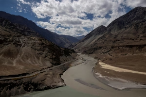
RAHIM YAR KHAN:Villagers living along the Indus in Liaqatpur tehsil have started shifting to safer places during the first week of July as rapid riverbank erosion threatens their homes and farmland.
Reports said areas near the Indus-Chenab confluence, including Beat Deewan, Beat Purharan, Bakshu Banhar, Jhok Gulab Shah, Ahmed Ali Laar, Basti Muhammad Yar Unhar and Khanpur Nahraka, are facing severe erosion. The affected settlements are located near Sheedani Sharif and Thul Hamza towns between the Indus and Chenab riverbeds and the Panjnad Canal. The Sukkur-Multan Motorway (M-5) runs parallel to the canal through Khanpur and Liaqatpur tehsils.
Residents have begun moving their livestock and household belongings to safer locations on tractor-trolleys on their own as the river continues to erode the banks.
The affected villagers complained that neither their elected representatives nor officials from the district administration and irrigation department had visited the area to address their concerns.
Demand construction of a protective spur to avert further losses
They said agricultural land cultivated with cotton, fodder and sugarcane, along with date orchards, had already been washed away by the river. Residents also attempted to slow the erosion by placing sandbags with the help of local boats, but their efforts proved unsuccessful. They urged the Liaqatpur tehsil administration to provide immediate relief and adopt measures to protect the vulnerable riverbanks.
When contacted, Assistant Commissioner Liaqatpur Ghulam Murtaza told Dawn that the affected belt had long been declared a floodplain and that riverbank erosion was a natural and recurring phenomenon. He said residents had repeatedly been informed about the risks of seasonal flooding and erosion.
He added that last Sunday (July 5), the Rahim Yar Khan deputy commissioner, accompanied by the superintendent engineer (irrigation), the executive engineer (EXEN), assistant commissioners, the district emergency officer and other officials, visited the affected areas to assess the situation, review preparedness, coordinate with relevant departments and ensure timely assistance if required.
The assistant commissioner said the district administration was closely monitoring the situation, with all relevant departments on alert to respond to any emergency.
The primary demand of the local population is the construction of a protective spur to prevent further riverbank erosion. However, he said such a project required detailed technical feasibility studies, hydrological assessments, engineering design and approval from the competent authorities before work could begin.
Published in Dawn, July 9th, 2026