HERITAGE: MAPS FOR A LOST CITY


As we navigate through the digital age, it’s easy to dismiss historic maps as mere relics of the past. With the convenience of Google Maps and other digital navigation tools, many of us may wonder, “What would we even do with paper maps in today’s world?” Nonetheless, maps possess rich value beyond their mere aesthetic appeal.
Maps are essential for all forms of spatial research, serving as the foundation for understanding past, current state and potential vulnerabilities, providing insight into the evolution of our cities and landscapes and offering unique perspectives on culture, society, even climate and weather-related events.
Present-day maps tell us what is where and allow us to create projections and simulations of what is about to come. When projections are made at the right time, they can even help us prepare for and address future crises. In fact, without proper cartographic analysis, urban planning and design would be akin to a doctor performing surgery without conducting the necessary diagnostic tests.
Regrettably, in the case of Karachi, there is a massive dearth of available maps. This complicates any attempt to find meaningful solutions to any woes of the city.
A new initiative hopes to create a reliable repository of maps about Karachi, as cartography is an essential source of information for current and future generations
Having realised this, I conducted in-depth research and analysis into Karachi’s maps, which led to the creation of ‘Karachi Cartography’ — an initiative focused on rethinking Karachi in the face of imminent threats.
For instance, the city is projected to be completely submerged — underwater — by 2060, according to a Climate Report issued by the British High Commission in 2021. That is, in just 37 years. To address this, phase one of the Karachi Cartography project called ‘Cartographic Analysis’ was launched, with a focus on water systems.
Developing solutions for the city’s infrastructural and climatic challenges without knowing the city’s history will only exacerbate dysfunctionality. Later, we hope to use these findings to raise awareness, provide training for adaptation and work towards community-led implementation strategies for resilience.
However, much of South Asia’s mapping history remains shrouded in mystery, which makes the dearth of maps for Karachi unsurprising from a geographic perspective.
Historising Karachi’s cartography (or lack thereof)
The earliest known satellite image of modern-day Karachi dates back to 1976, while the first publicly available satellite image only goes back to 1984, raising significant questions about the reliability of cartographic data predating this period.
The oldest known map of Sindh dates back to 150 AD. It remains unconfirmed, but the south-west corner of the map that is labeled ‘Calaca’ bears a striking resemblance to the present-day coastline of Karachi, with the edge looking like Cape Monze.
However, this remains speculative. Maps created using pre-satellite image technology are often challenging to interpret, as key information about their origins has been lost over time. It is hence difficult to rely on past maps.
Firstly, they do not account for the shifts in boundaries between land and sea that occur due to fluctuating sea levels, coastal erosion and, subsequently, reclamation of land by the sea. Secondly, pre-satellite maps were created without the benefit of modern tracing technology, leading to distorted proportions and inaccuracies.
But given that South Asia has been a significant sight for many invaders in their quest to expand their respective civilisations, how is it that Karachi remained neglected in the cartography project?
For instance, the conquering forces of Muhammad bin Qasim, who entered and seized Sindh through the port of Manora in the 8th century, did not undertake mapping in Karachi, despite their production of numerous other documents.
Early Islamic civilisation was known for its fastidious and innovative cartography, driven by the imperative of accurate orientation towards the Kaaba during daily prayers. Since Karachi — and the Subcontinent at large — lacked significant Islamic presence beyond scattered Sufi shrines, it was not made a focus on map-crafting by Islamic leaders. With few settlers and only transient visitors, detailed mapping for record-keeping purposes was never a pressing priority.
The city, prior to 1729, was primarily home to small fishing communities, who also did not prioritise record-keeping. The region saw frequent changes in power between the Khans of Kalat and the rulers of Sindh from 1729 to 1783, until it was eventually controlled by the Talpurs. In 1839, the British colonised the area and established it as a port.
History is often influenced by the viewpoint of the ruling power; this trend is also reflected in the case of Karachi.
As conquerors changed, so did the interpretation of the past, leading to alterations in the record. Although there is no conclusive evidence, it is widely speculated by several South Asian cartographers that the British colonial government destroyed important archival documents, as part of their “divide and rule” strategy to maintain their control over the Indian population.
This involved exploiting existing divisions between different religious and ethnic groups, and even creating new ones where none existed before. The ultimate goal was to keep these groups divided and prevent them from uniting against British rule.
As a result, the British demarcated new boundaries for provinces in India that were designed to ensure divisions were maintained. The new manipulated map with its new provinces created a system of governance that reinforced these divisions and made it more difficult for people to unite across these lines. It was important that the people have no recollection or proof of previous (non)boundaries.
Interestingly, the project of spatial boundaries was successful in manipulating the collective imagination of the people of British India, who were unable to think about their identities outside the margins of the borders.
Map in Identity Crisis?
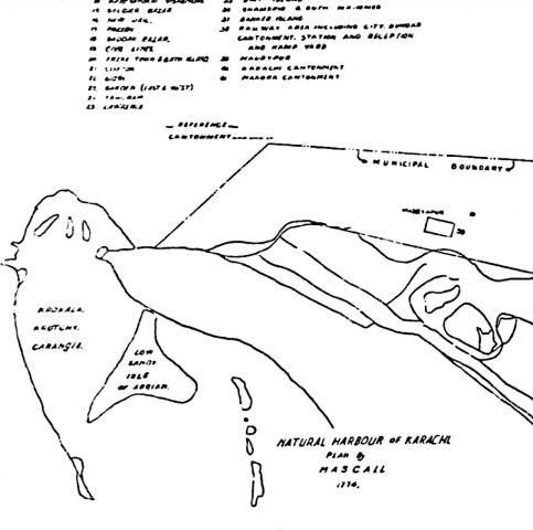
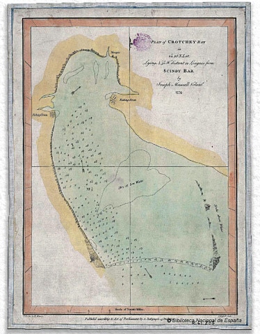
The sole available pre-British map of Karachi to show settlements was drafted by Lt. Joseph Mascall in 1774. But is it really a map of Karachi?
The map’s original version is presently held at the Goya Room for Mapping in Biblioteca Nacional de España (National Library of Spain), Madrid, where it is categorised as a map of Iran.
The ongoing research at Karachi Cartography has come to strongly question the categorisation of this map titled, ‘Plan of Crotchey Bay.’ Old sources often refer to Karachi as ‘Crotchey’, ‘Crochey’ and ‘Krotchey.’
One of the mapmakers behind this, Alexander Dalrymple (1737-1808), was a hydrographer to the East India Company (EIC). It would logically make sense for him to be working on ways to visually represent this new city in ways that would serve the EIC, which wanted to establish administrative control there.
Professor M. B. Pithawala, who has written extensively about Karachi and Sindh, shows an almost identical sketch also crafted by Lt. Joseph Mascall in “Sind’s Changing Map: An Album.” He writes about this, “... the natural harbour of Karachi pictured by Mascall (1774). It shows the low sandy island of Arrian (Kiamari?) Krokola, Krochy (Karachi), and the Manora rock.”
Further, the name ‘Scindy’ Bar used to describe the location on the map and “Sindh” have similar sounds due to the ‘consonant-vowel-consonant’ pattern: “s,” “n” and “d”, and similar vowel sounds make it easy to confuse one for the other when spoken aloud. Since there was no agreement on English spellings of any South Asian location names at that time, it is easily possible that they are both describing the same area.
Cartographers in South Asia continue to raise ethical concerns regarding the decision made by the National Library of Spain to label the map of Crotchey as a map of present-day Iran (then Persia).
The Great Archival Heist
The British were renowned for their meticulous documentation and preservation practices, which continue to be unrivaled decades after Partition. It has been 75 years since Partition and yet the quality of their pre-computer documents still remains unparalleled.
They brought the concept of archives as a distinct discipline to India in 1891, with the establishment of the Imperial Record Department in Calcutta. Here, among the records and manuscripts housed there were highly detailed maps created by the Survey of India.
However, after Partition, the ownership of these maps became disputed between India and Pakistan. To this day, a significant portion of Pakistan’s archival data remains at the National Archives of India in New Delhi. As no agreement was reached, the British reclaimed the most important documents, which are now housed at the Library of Congress in London.
The British didn’t just take the Kohinoor diamond, they also claimed South Asia’s records and documents as their own — the great archival heist.
In a similar vein, many historic maps of Pakistan, Sindh and Karachi have been scattered across the globe, finding homes in museums and libraries as far away as the United States, Japan, Switzerland, Slovakia and even the Czech Republic. What remains in Pakistan is only a handful of leftovers.
Post-Partition Maps and Archives
Post-partition, the Survey of Pakistan became the single national mapping and surveying government organisation. From using ‘Gill Sans’ font for labels to techniques of surveying, their team continued using the trends of their predecessors from the Royal Survey of India. They were shortly given the task to map the entire nation, including cityscapes like Karachi.
Unplanned development and construction made this task particularly difficult. Mapping the entire city would take anywhere between four and 10 years of continuous surveying. By the time the map was completed, given the dynamic and rapidly-changing nature of the urban landscape, it would have become obsolete.
Sindh Archives is home to all maps from the province for the period spanning 1820 to 1935 and boasts an exceptional preservation and conservation department, capable of restoring even the most damaged documents. Despite this, for years, the practice of storing maps was rudimentary, with them being folded into smaller folders and exposed to wear and tear, resulting in a cyclic process of preservation.
Fortunately, this practice has now ceased, and papers are stored straight to ensure their longevity. Although there are efforts to digitise the information, there is little clarity on when this will occur and whether it will be accessible to the public.
Despite their crucial role as evidence for spatial data, historic maps have become boiled down to being objects of beauty and prestige that remain coveted by the elite and passed down as treasured family heirlooms across generations, adorning the drawing room walls of the most affluent households to this day.
In the face of all of this, Karachi Cartography hopes to create a reliable repository of maps, as they are essential sources of information for the current and future generations to work to reimagine the city in a way that serves not just those with who can afford it, but everyone who resides within it.
The writer is an architectural designer turned urban researcher and activist. She is the founder and director of Karachi Cartography. She can be reached on email
khalid.namra@gmail.com.
She tweets @khalid_namra
Published in Dawn, EOS, March 19th, 2023


