

‘Chicken necks’: the one grouse that the British colonial rulers held with South Asian cartographers. The British lamented that territories in South Asia had not been cut in straight lines. They reasoned that territories carved as a complex mesh of ‘chicken necks’ — winding and irrational — could not be governed as effectively as ones with straight lines. Little did the British understand that chicken necks are the best way to construct constituencies of choice.
The new delimitations in Karachi are a complex mesh of chicken necks — arguably more chicken necks drawn than ever before on electoral demarcations in Karachi. Follow the boundaries of the new demarcations and a pattern emerges: new National Assembly constituencies drawn up in Karachi have created ethnic enclaves.
What’s worse, it didn’t need to be this way since mathematical calculations carried out by the Election Commission of Pakistan (ECP) all check out. Final census results put Sindh’s population at 47,886,051 with a 23.05 percent share in the national population. In 1998, Sindh’s population was registered as 30,439,893. The right formulas have been employed to hand Sindh 61 seats in the National Assembly. Karachi has one more National Assembly seat than the last time around, taking its tally to 21.
The extra seat has been allocated on the basis of population; it was moved to Karachi because Jacobabad district lost one seat after its bifurcation back in December 2004. Till then, there were three National Assembly seats from Jacobabad district. After the bifurcation, Kashmore became a district as well. Both Jacobabad and Kashmore were handed one National Assembly seat each, with the extra seat subsequently shifted to Karachi.
The new constituency delimitations in Pakistan’s largest metropolis point to more than political gerrymandering. They will have the effect of dividing an already polarised city further along ethnic lines
And yet, somehow, somewhere, despite intricate calculations, things have gone terribly out of kilter.
PRINCIPLES OF DELIMITATION
The year was 2011 and Chief Justice Iftikhar Muhammad Chaudhry was riding the crest of popular approval and support for his suo moto proceedings. One of the cases he heard at the time pertained to insecurity and violence in Karachi that was putting the lives and property of citizens at stake. After careful consideration, his bench wrote the following (as part of an) order:
“[We] further observe that to avoid political polarisation and to break the cycle of ethnic strife and turf war, boundaries of administrative units [such as] police stations, revenue estates, etc., ought to be altered so that the members of different communities may live together in peace and harmony, instead of allowing various groups to claim that particular areas belong to them and declaring certain areas as [no-go] areas under their fearful influence ... on similar considerations, in view of relevant laws, delimitation of different constituencies is also to be undertaken with the same object and purpose.”
In other words, to safeguard the peace of Karachi, the city needed multi-ethnic constituencies and any delimitation process ought to keep that in mind. Since it was an order, it set precedence. And legally, once a precedent is set, it is difficult to have it overturned.
But the new constituency map in Karachi is showing a different trend: boundaries have been drawn in such a manner that majority ethnic groups in various constituencies have been reinforced in terms of numbers — in other words, most constituencies resemble the shape of an ethnic enclave. Simultaneously, members of other ethnic groups have been removed from the same constituency. As a result, “Mohajir areas” have become more Mohajir, “Sindhi areas” more Sindhi, and “Pashtun areas” more Pashtun.
The legal precedence set by Iftikhar Chaudhry has now been broken.
Undoubtedly the new arrangement provides an opportunity to various ethnic groups to select their representative from within their community and send them to parliament. But for the past 30 years, this exact principle has seen hundreds fall to violent conflict between political parties in Karachi — often under the guise of “ethnic conflict.” Chaudhry’s argument, therefore, about multi-ethnic constituencies enabling different communities to learn to co-exist has great wisdom that is unfortunately being ignored by the ECP.
But that is where the story of precedence ends. What follows is how the ECP’s cartographers employed the use of chicken necks to create constituency boundaries.
The “principles of delimitation”, as defined in the Election Act, 2017, state that National Assembly constituencies will be drawn up through the distribution of population. The boundaries of these constituencies ought to be continuous — a locality situated miles off a constituency cannot become part of that constituency. And constituency boundaries need to be cut in a certain way — zigzag and clockwise from the north.
Constituencies will either share boundaries with its neighbouring constituency or abut a main road, a railway track, perhaps a river, or even a nullah. In the former, the rule of demarcation is straightforward. But the second case is where it gets interesting: members of the same ethnic group might live on both sides of a main road but they cannot be part of the same constituency — the main road divides constituencies irrespective of ethnic composition.
Then there is the distribution of administrative units (police stations, for example), communication facilities, and public services. The more rounded electoral constituency should show a balanced distribution of these services.
None of these principles have been followed, let alone followed to the tee. The outcome of delimitation carried on these terms is that ethnic stereotypes that exist in official imagination have now been formalised and reinforced.
SLEIGHT OF HAND, TWIST OF MAP
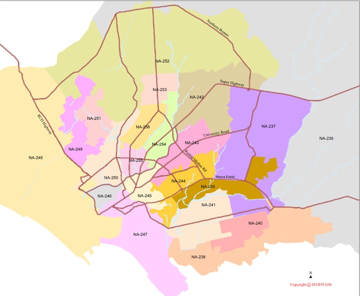
Anyone who has arrived in Karachi by plane has had the pleasure of travelling along Sharae Faisal, the major road that connects the airport with the city proper. And some might even be familiar with the Karsaz intersection on Sharea Faisal, which leads towards naval property en route to the National Stadium.
In principle, Sharea Faisal divides various constituencies. But in some of the newly-carved constituencies, the main road serves no purpose. In NA-244, Sharea Faisal has been crossed in one case to include Urdu-speaking settlements into a constituency that is already dominated by an Urdu-speaking population.
On the surface, it seems pointless for a law to be violated to provide insignificant benefits to Urdu-speaking representatives. But the converse is what makes it interesting: the removal of an Urdu-speaking settlement on the other side provides marginal benefits to the Pakistan Peoples Party (PPP) in a constituency that used to be hotly contested between Muttahida Qaumi Movement (MQM) and PPP. In a way, it reduces the number of obstacles a PPP candidate has to overcome in order to win this constituency. But equally, it also takes away the burden of serving a different ethnic community — something that the PPP and MQM have both struggled to deliver.
Another ethnic enclave of note is NA-250, which binds various Pashtun populations together. Although much of the moving around of constituencies’ territorial boundaries directly impacts the MQM and the PPP, Pashtun interests have been safeguarded in NA-250. For a long time now, Pashtun interests have been at the mercy of either or both the MQM and the PPP. And perhaps because of a blood-soaked history, NA-250 brings together even outlying Pashtun populations into the constituency.
Irrespective of the politics on ground, it is important to understand how territories are manipulated.
On the surface, it seems pointless for a law to be violated to provide insignificant benefits to Urdu-speaking representatives. But the converse is what makes it interesting: the removal of an Urdu-speaking settlement on the other side provides marginal benefits to PPP in a constituency that used to be hotly contested between MQM and PPP.
Consider, for example, the (new) constituencies of NA-239, NA-244, NA-249 and NA-251. As visible in the map, the boundaries of these are all filled with chicken necks. NA-239 stands out, in fact. One narrow strip of the constituency penetrates into the jurisdiction of NA-237 — also through chicken necks.
Officials associated with the Pakistan Bureau of Statistics (PBS) maintain, however, that there is a justification to creating chicken necks. They argue that in squatter settlements, for example, there are no proper roads to demarcate territories. To the trained eye, however, the presence of chicken necks automatically indicates some foul play in the delimitation process.
Chicken necks are typically introduced when new districts are being carved. The next stage where chicken necks can be introduced is in the census delimitation process. And the third stage where they can be (mis)used is in the process of electoral delimitation. But it is the foundation which, if corrupted, will affect the rest of the processes. The base of any good system is an accurate census, because it determines political representation in the assemblies, delimitation of electoral constituencies, and the distribution of funds to federating units by the National Finance Commission.
In 2007, an exercise for delimitation was carried out for the 2008 census. But since the 2008 census never took place, these results remained intact for the next census, which was held in 2011. But the data of the 2011 census was flawed and after much furore, it was subsequently discarded without any official reason. Part of the objection was that political workers had fudged data at block-level.
Here’s the twist: the maps drawn up in 2007 were also used as the foundation for census delimitations in 2017 to divide Karachi into housing blocks.
(This is not to be confused with electoral delimitation, which was made on the provisional results of the 2017 census.)
In fact, 2017 was the first time that all major urban centres of the country were mapped through satellite imagery. This begs the question: why were the 2007 maps being used in the first place?
The answer is rooted in how drawing maps on paper (instead of relying on satellite imagery) enables the moving around of boundaries. If the same census delimitations were to be used for electoral delimitations, the results would be rational and consistent. But with such a big difference existing between census delimitations of 2007 and 2017, the probability of foul play increases manifold.
HISTORICAL IRRATIONALITIES
The district of Malir has historically been dominated by the PPP. The party draws its power largely from Sindhi and Baloch communities in the locality although, of late, it has also had help from police officials posted there who are deemed to be loyal to the party.
Malir is divided into two halves: rural and urban. In this division lies the basis of a great ideological divide.
After General Pervez Musharraf introduced his local government system in 2001, a controversy erupted over perceived or alleged attempts to ‘bifurcate Sindh on linguistic basis.” Musharraf’s government had merged Karachi’s five districts — East, West, Central, South and Malir — into a single district.
Meanwhile six districts were carved out of districts Hyderabad, Dadu, Larkana and Jacobabad. Hyderabad became a cautionary tale: all Sindhi-dominated localities were separated from Hyderabad proper while the city was largely left only with citizens from Urdu-speaking backgrounds. In Karachi, however, when the Sindhi-dominated district of Malir was merged with the Karachi district, citizens cried foul over the different standards being maintained by the Musharraf government — one for Karachi and the other for the rest of the province.
Musharraf’s supporters responded by pointing to urban localities of the constituency — Gulshan-i-Hadeed, Steel Township and Pipri — as having been classified “rural,” arguing that such dichotomies have been created by PPP. The population of these areas hovers around 250,000 people.
In 2018, however, Malir is witnessing some grand changes. The registered population of Malir in 2017 is 2,008,901, an increase of about 106 percent from 1997. Clearly, population pressures over two decades have increased as well. While the extra constituency handed to Karachi has gone to Malir, there are new housing projects cropping up in Malir that have brought more people to the district. Constituencies have also been adjusted in a way — through chicken necks — to hand PPP a clear advantage in the three National Assembly seats. This has happened by chewing up bits and parts of adjoining constituencies, also dominated by PPP. A marginal decrease in other constituencies does not impact them as much as they provide reinforcement in numbers to the new constituency.
RE-IMAGINING KARACHI?
The tragedy of Karachi’s political fabric is that irrespective of ideological bents, every mainstream actor (not reliant on religious politics) becomes identified with an ethnic group.
In popular imagination, PPP is a Sindhi party, the MQM is Urdu-speaking, and the Awami National Party (ANP) is a Pashtun party. Even parties such as the Pakistan Tehreek-i-Insaf (PTI) and the Jamaat-i-Islami have in recent times been touting their leadership claim over the Urdu speakers. Similarly, even labour unions aren’t spared of this ethnic-coloured phenomenon: a union backed by the MQM, for example, is identified as Urdu-speaking and by extension, safeguarding the interests of its ethnic group.
When the same dynamic plays out on the streets of Karachi, localities get marked as being dominated by one ethnicity or the other. Ultimately this translates into a tussle over power and who gets to control (very) limited resources. A recent manifestation of how this struggle plays out in governance is the stripping of all meaningful power and authority of the MQM-led Karachi government, by the PPP-led Sindh government.
The new delimitations in Karachi announce a shift in who has ethnic dominance over the city: PPP.
The last time delimitations were made in Karachi, under the watchful gaze of Musharraf, the outcome was the financial squeezing of districts that didn’t traditionally vote for MQM. Back then, street wisdom dictated that MQM could work in others’ areas but nobody else could work in MQM areas. Lyari, the locality dominated by the PPP, was among the territories to be violently contested. Musharraf’s gerrymandering was meant to ultimately provide entry for the MQM in such localities, as saviours of populations that didn’t traditionally identify with them.
There is no military general at the helm this time round, but in carving the new constituencies, the ECP is guilty of having manipulated population groups to create ethnic ghettos. The prime beneficiary this time round appears to be the PPP although the MQM-Pakistan and the Pak Sarzameen Party (PSP) also stand to benefit in some localities. But similar to last time, this year’s delimitations are ultimately to provide entry for PPP as the saviour of populations that don’t traditionally identify with them.
The see-saw nature of this change, however, goes beyond an election or two — or for that matter, also beyond Karachi.
The provincial capital has long been claimed by a number of actors, all of whom declare themselves to be representatives of one ethnic group or another. The influx of the ‘Mohajir’ [migrant] community to Karachi in 1947, and then again after the formation of Bangladesh, underpins the MQM’s claim over Karachi.
In turn, this claim of ownership is what breeds mistrust among parties dominated by ethnic Sindhis. But Sindhi nationalist parties take this mistrust to an extreme, often arguing that “migrants” need to go “home” if they arrived in Sindh — not Pakistan — after a certain time. This argument, and the dream of reclaiming Karachi from the clutches of the “terrorist” MQM, underpins the claim over Karachi of many Sindhi nationalist parties.
For many years, PPP has played the dual role of a Pakistani nationalist party, when in government, and a Sindhi nationalist party, when in opposition. And for a long time, PPP has been derided by Sindhi nationalist parties for its ideological duplicity and over its inability to “liberate” Karachi. The nationalists are irrelevant in the larger scheme of things, but they do make enough noise along with the civil society to be a credible irritant.
This time, however, the tables have turned.
Not only does the PPP have a clear electoral majority in cities and towns not named Karachi, it will also likely emerge as the largest party in the provincial capital. And in doing so, the PPP would have already achieved the notion of having captured Karachi, thereby routing any resistance being put up by Sindhi nationalist parties as well as their narrative of creating imagined enemies. The significance of winning in Karachi goes beyond numbers; it is symbolic.
Second, a run at near-absolute dominance in Sindh gives PPP a shot at forming the government at the Centre. In an interview published in daily Dawn, PPP chief and former president Asif Ali Zardari argued that future governments in Pakistan will likely be coalition set-ups. (The sub-text to this statement is that ‘national’ parties do not exist in this climate, politics has gone provincial, and mainstream actors will all have to turn their attention at winning their provinces.) Towards that end, the more National Assembly seats that can be eked out in Sindh will help with PPP’s claim over forming the federal government.
EPILOGUE
The devil, as they say, is in the details.
The law governing national polls later this year is the Election Act, 2017. Enacted on October 2, 2017 — therefore having the assent of this country’s elected representatives — it was supposed to “amend, consolidate and unify laws relating to the conduct of elections.”
But what exactly did the lawmakers put their names to?
The Act, over a hundred pages long, is the ultimate guidebook for how elections will be conducted, the powers and rights accorded to the Election Commission, the procedures to follow before elections, before and after polling has closed, how to record votes, and so on. It even has procedure defined to solve a party’s internal dispute.
But the last chapter of the law, titled ‘Miscellaneous’, has a surprise waiting: Section 236 of the law informs us that the courts have absolutely no jurisdiction over matters of the ECP.
Sub-Section 236-1 reads as follows: “No court shall question the legality of any action taken in good faith by or under the authority of the Commission, the Commissioner or an election official, or any decision given by any of them, or any other officer or authority appointed under this Act or the Rules.”
There is absolutely no definition of what constitutes “good faith.” This phrase can legally be interpreted in many different ways.
Moreover, Sub-Section 236-2 prevents any court from questioning the “validity of the electoral rolls prepared or revised under this Act or the legality or propriety of any proceedings or action taken by or under the authority of the Commission or a Registration Officer.”
And Sub-Section 236-3 hits it home: “The validity of the delimitation of any constituency or of any proceedings taken or anything done by or under the authority of the Commission, under this Act, shall not be called in question in any court.”
This isn’t going to be an election influenced by returning officers; it is an election that has been decided by cartographers. The ones who drew the “chicken necks” this time round.
Ahmed Yusuf is a member of staff. He tweets @ASYusuf
Dr Syed Nawaz-ul-Huda is a senior data analyst associated with Dawn-GIS
Published in Dawn, EOS, June 3rd, 2018


