

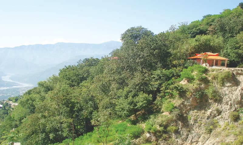
Negotiating sharp turns as we ascended to a higher altitude like a slithering serpent was no less than a scary experience for us, forcing us to fasten our seat belts and hold on tightly to our seats. Initially, an amalgamation of urban and rural and the not-too-far away wilderness for most part of the scene constitute the panorama of Allai in district Battagram.
A place with multifarious social and ecological features — gushing water, snow covered mountain summits, terraced fields, forests, meadows, hiking tracks and mountain dwelling culture. Ask anyone in the area about Lait and Shaam — which are considered very beautiful birds of the highland — and they will keenly tell you that these are the vernacular names of male and female monal pheasant.
Thakot bazaar is situated on the right side of the mighty River Indus, locally called Abasin; from here one can also see the administrative boundary of the neighbouring district Shangla on the left side of the Indus along the Silk Route which joins district Kohistan ahead. Turing right from the bazaar the road leads you to Allai; unfortunately the road is metalled only up to a short distance.
If you can bear the poor road condition, district Battagram has plenty to offer to nature lovers
Availing a short break from work, this trip was being made to see the charm of Allai that had captivated my mind for some time since it was mentioned to me by a friend. Finally, I had the opportunity to embark on the journey.
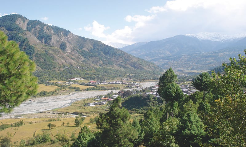
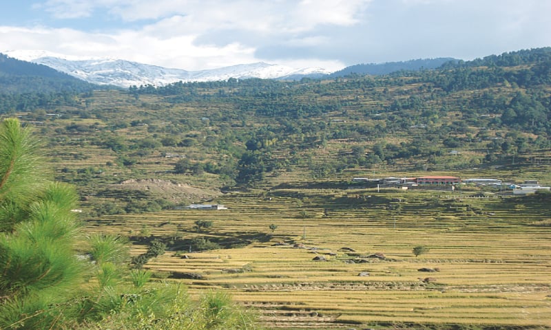
poor condition of the road is quite a setback for those wishing to travel up to Allai but as long as one is ready to brave that, one can witness a panorama of natural landscape that unfolds as one goes up the mountain range. Travelling further ahead, the Allai and Kohistan mountains open up and as one catches a glimpse of the place, one can visualise the natural panorama lying ahead. Though in the beginning the mountains appeared denuded, the scene changed with the gradual appearance of a vegetation cover as we moved on.
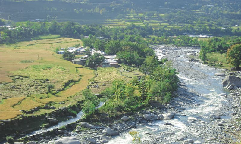
Further ahead, the road bifurcates, and one has to make a bit of a decision whether to opt for the upper road which appears better and planned, or to take the lower road which is a sort of a short cut, as well as the preferred option. Watching the local kids playing by the river bank adds richness to the surroundings.
Driving ahead, one could see the mountains dotted with terraced fields of rice, potato, peas, beans, walnuts, apple and pears on fringes of the relatively small growing areas. November is the month when most of the fruits are plucked and sent either to the market or stored for local consumption. On our way up, we saw unripe, black amlook, which when ripen and turn orange, are sold in the cities mostly in November and December.
And that’s not all that you get to see. A few waterfalls appear as a string of water fed by glacial water from the mountains. The nascent snow-covered mountain tops add to the beauty of the place. As the day progressed and meal
time arrived we could see smoke spouting from chimneys of the houses made of stones, with roof tops of glittering galvanised sheets.
Though the track is only about 30km long, it took us more than a couple of hours to reach our destination due to poor condition of the road along the foothills and the sharp blind turns. Going to Allai would remind tourists of their
journey they may have made to Chitral via Lowari Top with its peculiar zigzag road. The journey to all these destinations is more or less the same; in the case of Allai, however, the road is supported by retaining walls to prevent sliding in rainy conditions.
On this meandering road, drivers have to be extra cautious at the blind sharp turns and watch out for any vehicle coming from the opposite direction. As we gained higher ground, the smaller habitation and Abasin appeared. We experienced stones that had rolled down from the mountains on to the road creating obstacles and making driving trickier, besides the intermittently metalled and kacha road washed by rains.
With the onset of autumn the autumnal colours in the broad-leaved forests add to the beauty of the area. The vegetation further changes from scrub to coniferous forest which is the favourite habitat of the black bear and other associated fauna. Sadly, we were told by locals that some people had killed a black bear and that the concerned field staff had taken a handsome amount of fine from offenders for committing breach of law.
Fed by glacial water from the high mountain tops, such as Chilsar, the Allai river flows across the valley and adds to the natural beauty. The cold water of the river is a refreshing experience especially in summer. The atmosphere is laden with the peculiar smell of ripening rice in paddy fields, where we could see people working.
The area has a rich history with findings from the period of Alexander and the Mughal era. I had an opportunity to go to Banjan which is an open area to catch a bird’s eye view of the valley. One of the best sites in the area is the Chor Valley which is rich in biodiversity and natural beauty with a landscape of pastures and dense forest on the lower reaches. However, to go there, one should plan one’s visit accordingly and take along tents for camping as it could take few days to go and come back.
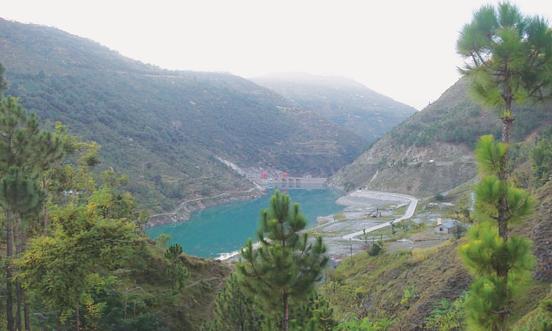
Allai Dam is situated along the Thaloos Road. The dam is fed by Allai Khwar whose source is Khapero Sukai, the highest peak in the area and covered with snow for most part of the year. The high mountain peaks which mostly play hide and seek with the clouds, present us a very engaging view. The power house at Sechbeyar is fed by water from the dam. Interestingly, about a 3km-long tunnel across the mountain supply water to the power plant to generate electricity. It was mesmerising to see the dam at first sight as it appeared after meandering drive in the mountains.
Its emerald green water proved to be a major attraction of the area. We remained there for some time to inhale fresh air and captured the best of the scene in our memory.
It was hard to leave the place and but we had to leave as it was getting late and all the distance back had to be covered.
Published in Dawn, Sunday Magazine October 18th , 2015
On a mobile phone? Get the Dawn Mobile App: Apple Store | Google Play


