
Dil Ka Pathar. Chhota Dil Ka Pathar. Ganga Ram. Jamna Ram. Mohabat Ram. Chachu Ram. Nanda Devi. Tanki Maar. Gabu Ki Maar. Talaar. Koro.
They sound like the titles of old forgotten Subcontinental movies, but are, in fact, centuries-old names for underwater landmarks in the Arabian Sea. For example, Dil Ka Pathar [Stone of the Heart] — both big and small — are reefs that are shaped like a heart; maar means the area where one can find lots of fish; and koro means a sandy sea-bed.
Every fisherman knew where they were. None of them appeared on any chart. Passed down through generations of Pakistan’s Sindhi and Baloch coastal communities, this oral archive of reefs, rocks and channels formed a mental map that guided fishermen and divers long before the global positioning system (GPS) was widely available.
MAPPING THE DEEP
It’s time to convert this oral map into a digital one, preserving generations of maritime knowledge while making it accessible to fishermen, researchers and scuba divers to find fish, sight dolphins, shipwrecks and coral reefs. The atlas could also reveal the movements and habitats of iconic Arabian Sea species, including whale sharks, blacktip and tiger sharks, and the critically endangered guitarfish.
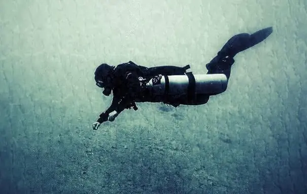
Fortunately, Pakistan has someone willing to take on the challenge: 50-year-old Mansoor Ahmed, one of a handful of Professional Association of Diving Instructors (PADI)-certified trainers in the country.
For centuries, Sindhi and Baloch fishing communities have navigated the Arabian Sea using a mental map of reefs and channels and names passed down orally through generations. Now, a Karachi-based diver is working to transform this inherited knowledge into a digital diver’s atlas
Ahmed is creating a “diving map” — a Karachi Coastal Atlas that brings the region’s underwater world to life for marine enthusiasts. It will guide surfers to good waves, warn them about strong undercurrents, point divers towards fish habitats, identify safe snorkelling and underwater photography spots, and fishing grounds for hunters.
“My aim is to inspire young people to understand and celebrate our maritime heritage — only then will they protect and preserve it,” explains Ahmed. “Unfortunately, most Karachiites know little about local reefs, fishing grounds, marine life or even mangrove forests,” he tells Eos.
Once complete, the map will help explain Pakistan’s coastal environment. The self-funded project, which is both complicated and time-consuming, has already identified around 50 dive sites. “But there could be many more amazing places that remain unexplored,” he says.
THE RISK OF REVEALING TOO MUCH
“I’m all for it,” says Dr Sohail Thobani, a veteran and well-known Pakistani diver, while welcoming Ahmed’s effort to map the dive sites. However, he fears mapping could come at a cost.
“We often don’t disclose the locations of our dive sites because it can lead to overcrowding of divers to one place, which may harm the fragile reefs,” he tells Eos. “Damaging the reefs means the fish will disappear.”
He has already witnessed a sharp decline in marine life. “In the 53 years that I’ve been diving, I’ve seen barracuda and grouper populations dwindle dramatically,” he says.
But many countries have well-established dive maps, yet their reefs and fish populations continue to flourish and scuba divers continue to visit and enjoy them. “The difference is that, in many places, local marinas and dive operators have installed permanent mooring buoys at dive sites,” Dr Thobani explains.
“These are connected to anchor lines fixed away from sensitive reef areas, allowing boats to tie up to the buoys instead of dropping anchors,” he adds. “Every time a boat drops its anchor, it destroys the coral on the sea floor and, in turn, the fish habitats.”
HOW THE ATLAS WORKS
Ahmed plans to begin fieldwork in September and has already enlisted six local divers to help cover sites he cannot himself reach. “Anyone is welcome to join,” he says, “but they must be certified divers.”
Ahmed also points that the project, which is not intended to generate income, will be carried out in two stages. In the first stage, a boat equipped with a marine GPS device will record precise latitudes and longitudes of dive sites and underwater features such as reefs, caves, rock formations, channels and shipwrecks.
While the GPS cannot see underwater, it can accurately mark the location directly above an underwater feature. “If you want to visit a coffee shop, you first need its address before you can get there. It’s no different with a dive site,” Ahmed explains.
“The second stage will involve underwater surveys carried out by divers to verify sites and develop a more detailed educational atlas of Karachi’s coastal environment,” continues Ahmed.
Ahmed has deliberately kept the project independent — no large organisations, no government involvement.
PEOPLE OF THE WATER
Twenty-eight-year-old Irfan Abdul, a certified free-diver from Abdul Rehman Goth, is among the local people who will assist Ahmed with the project. He hopes the diving map will transform how local guides showcase the region’s underwater world.
“When divers hire us, we often don’t know where to take them because there are so many options,” he tells Eos. “A map would help them identify sites of their interest.”
Abdul takes visitors out to sea for surfing and free-diving and is famous for his cooking of exotic seafood. Deeply connected to the coast, he laughs as he says, “We are people of the water. We like the taste of salty water; to us fresh water is tasteless.”
Volunteering as a marine conservationist, Abdul has witnessed the slow degradation of the sea. “We have extraordinary biodiversity, some of which is found nowhere else,” he says. “But careless dumping — by city residents and even coastal communities — is slowly destroying marine life.”
The atlas may eventually guide divers to reefs, surfers to waves and conservationists to polluted sea beds. But its greatest achievement could be preserving something far less tangible: a centuries-old maritime vocabulary that exists largely in memory.
Before satellite navigation, Karachi’s coast was mapped through stories, landmarks and names passed from one generation to the next. Ahmed hopes that, long after the last fisherman who learnt those names by heart is gone, places like Dil Ka Pathar, Jamna Ram and Mohabat Ram will still have a place on Pakistan’s maps — and in its collective memory.
The writer is a freelance journalist based in Karachi. X: @zofeen28
Published in Dawn, EOS, July 5th, 2026


