
 MIAMI, Aug 27: Hurricane Katrina bulked up in the Gulf of Mexico on Saturday for a second and potentially more deadly assault on the US coast after killing seven people on its trek across southern Florida.
Watches and warnings were posted for parts of the Louisiana coast, including vulnerable low-lying New Orleans, alerting residents to expect hurricane-force winds within 36 hours.
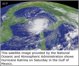
By 11am (15000 GMT) on Saturday, the hurricane was 405 miles southeast of the mouth of the Mississippi River, with winds near 115 mph (185 kph).
The storm was larger and more powerful than when it hit Florida’s southeast coast on Thursday and was expected to swing gradually west-northwest, the National Hurricane Centre in Miami said.
The projected path could see it come ashore anywhere between the storm-scarred Florida Panhandle and the Louisiana coast west of New Orleans. But computer models pointed to a more westerly track, putting Katrina ashore on Monday near the Louisiana-Mississippi border.
“That’s bad news for New Orleans and better news for us,” said Florida’s top meteorologist, Ben Nelson.
The hurricane could disrupt US oil and gas rigs in the Gulf and some energy companies had begun evacuating workers from their platforms.
Katrina posed a great risk of flooding all along the northern Gulf coast.
The hurricane centre said it could become a Category 4 storm on the five step Saffir-Simpson scale by Monday — a potentially catastrophic hurricane with 131 mph-plus winds capable of causing widespread damage. Meteorologists have warned this hurricane season could be unusually active.
Florida Gov Jeb Bush said residents in the Florida Panhandle would be ready.—Reuters


