

Kumrat valley — the hidden gem of Khyber Pakhtunkhwa
Kumrat valley has become the new big thing for the last couple of years with fables of its dense pines, tall dark mountains, waterfalls and raging rivers. The valley is in the region of upper Dir and was until recently not open to the outside world. Besides the local conservative traditions, there were security concerns which made upper Dir out of bounds for some time. However, thanks to the government, the area is now peaceful and local economic growth generated through tourism is fast taking care of some of the misconceptions surrounding the area. Kumrat is now welcoming tourists with open arms and so last summer, I found myself enjoying the benevolent hospitality of these mountain people.
Since my longtime friend Yakub has partly shifted from the US to Pakistan, I am finding myself more and more on the roads to nowhere. We left Lahore at 6 am on a sunny September morning and in four hours, diverted to the Swat motorway from the Karnal Sher Khan Interchange. In six hours, we were looking at Churchill’s picket at Chakdara where Winston Churchill stayed as a war correspondent during the famous tribal uprising of 1897.

As we proceeded towards Timergara on the Dir-Chitral road, the beautiful Panjkora river joined us. Yes, this road takes you to Chitral in about 10 hours after crossing the famous Lowari top. We reached the beautiful Timergara on the banks of Panjkora river in seven hours from Lahore. Timergara has a few reasonable hotels to stay in and a lovely Dir scouts mess to lounge in if you have the right connections. But in Robert Frost’s words, we had miles to go before we could stop and sleep so we continued on the Dir-Chitral road alongside the river.
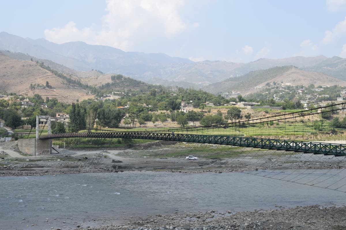
About an hour from Timergara, the road bifurcated towards Kumrat valley on the right and we entered a gorge travelling along the river. Up until now, the road was perfect but then it started to become a bit tricky in terms of pot holes and broken patches. However, it was still an easy road to drive on. We crossed small mountain towns with men and boys wearing round prayer caps and the women mostly in veils of the shuttlecock variety. The rough road was taking its toll on us and to our luck, no one had a good idea of how far Kumrat was. We were hungry but could not find a reasonable place to break bread and this is when we already travel with pretty low expectations. This was the real Pakistan, simple people living their lives in poverty but they looked happy.
It took us four hours from Timergara to reach Thall town, known more for the majestic 19th century wooden mosque by the river. We took a break to explore the historic mosque made from huge planks of Deodar trees and embellished with intricate wood carvings and motifs. The mosque looked somewhat similar in architecture to ancient mosques in Shigar and Khaplu constructed by Kashmiri craftsmen.


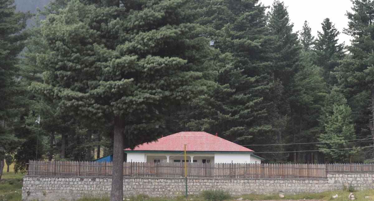
Our destination, the forest rest house, was another hour from Thall town up in the Kumrat valley. There was almost no road from Thall bazar to the Kumrat forest rest house and only SUVs with good clearance worked here. At around 6pm, we entered the well-located and well-maintained forest rest house at the mouth of Kumrat valley.
The rest house was set in the back drop of tall black mountains under dense pines and the sound of the river gushing in the back; giving off a surreal feeling. The only thing missing in all this was some good food after a long tiring drive but we were lucky to have an excellent cook at the rest house. After having some late night tea under a starry sky, it was now time to sleep.
The next morning, it was trekking day to the Jahaz Banda meadows. And for me, this means a maximum of four to five hours of trekking in the whole day so it doesn't get too strenuous. We first came down to Thall Bazar and took the main road towards Kalam. Just to clarify, Kumrat valley is to the north of the main Dir-Kalam road, whereas Jahaz Banda is to the south of this main road. After about 10 minutes, we took a small jeep trek into the Darwaza village on our right and it took us around an hour of some tricky bends, a number of villages, and some beautiful views to reach the Jhandrai village, the launching pad for the meadows. Here, there is a famous host, Raja Taj Muhammad, who runs a small hotel with a museum in the village, offering a one stop shop for all tourism related matters. But unfortunately, we did not get to meet him.
If you want to save some 15 minutes of trekking time, you can actually drive past the Jhandrai village on a narrow jeep trek which soon crosses a bridge on a mountain nullah and further upwards until the trek meets a dead end with ample parking space and another small tea kiosk and lodging place. We parked our vehicle here and had tea at the local dhaba before starting the trek. The dhaba owner told us that this was a good season and a lot of people had been coming in and he was making good money. We also hired a not-so-friendly guide with a horse to take us to Jahaz Banda, lest we got lost. And before you make any guesses, the horse was just an insurance and we almost didn’t use it. My friend had brought two extremely useful walking sticks this time around and that made our lives much easier.
The hike took us through dense pine forests and the first 30 minutes' stretch was quite tough due to a sharp ascent before the ground became a bit leveled with a continuous upward gradient. We crossed several crystal clear streams and passed through small villages where sometimes even governments seldom manage to reach. It took us about two hours of continuous walk to reach the meadows.


The meadows were flats, the size of five to six football grounds in all, surrounded by snowcapped mountains and tall green pines. Lucky us, there were not many people as the tourist season was now closing. However, I could see what happened in the last few months through the piles of garbage and plastics everywhere. Add to that, the locals were constructing all sorts of hotels and kiosks there which were not only shabby but also very unfriendly to the environment. Fortunately, the meadows are still beautiful, just like Murree is still beautiful despite the rampant and ruthless commercialism that it has been living through for the last 40 years. After a short rest break and some steaming hot tea, our guide takes us to the beautiful Jahaz banda waterfalls about 15 minutes from the meadows. Reaching the waterfalls was a precarious trek. I have never seen such beautiful waterfalls from this close in the middle of dense jungles. You can also trek further to the beautiful Katora lake three to four hours away. However, we left it for another day. But if you're planning to trek to Katora lake, there are a few makeshift lodging places in the area where one can stay overnight. Our guide also told us about another three days trek that leads from Jahaz Banda to Kalam in the Swat valley. But for now, that trek into Swat is a dream in our books.

It was now time to return to our basecamp which was downhill and while we were breathing just fine, the trek back took a toll on our hamstrings. People who trek often can relate to this and at times you just don’t know whether trekking up is more strenuous or trekking down. Enjoying the sun setting in the beautiful mountains and the streams shining silver in the sunlight, we reached our base camp in about two hours. In another two hours, we were back at our rest house in the woods waiting for the lovely tea and supper before we going to sleep.
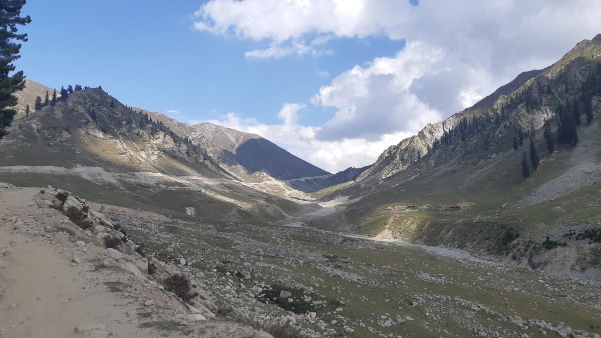
Next morning, we drove further into the real Kumrat valley. These were one of the most dense flat pine forests I have ever been to and the Panjkora river was flowing along the dirt trek, dividing at places into many channels with crystal clear waters and mountains all around. It's like a huge and endless gorge. Unfortunately, there were makeshift camping spots, just like Jahaz Banda, that are totally unregulated and with minimal respect for nature. Anyway, as we drove deeper into the gorge, it became quieter and more serene. We stopped to have a look at the famous Kumrat waterfalls which were a little less magnificent than the Jahaz Banda ones, and again littered by tourists with plastics all around. I wish we can be a bit more responsible with what we do on vacations and be more environment friendly.


We drove further on to 'Kala Chashma’ or the black spring, owing its name to the black mountains. The vehicle stops here thankfully, and I would say, it’s here that the real Kumrat valley starts. We then trekked for some time in the jungle along the gushing river and streams coming from far off mountains and the locals told us that it takes a few days from here to reach the Shandur valley in Chitral. I saw another dream in the making here, but maybe another day. At this point, we could see small villages of Gujjar shepherds far in the mountains and one can keep guessing how our mountain people manage their lives in such an inhospitable terrain. But maybe they are happy.
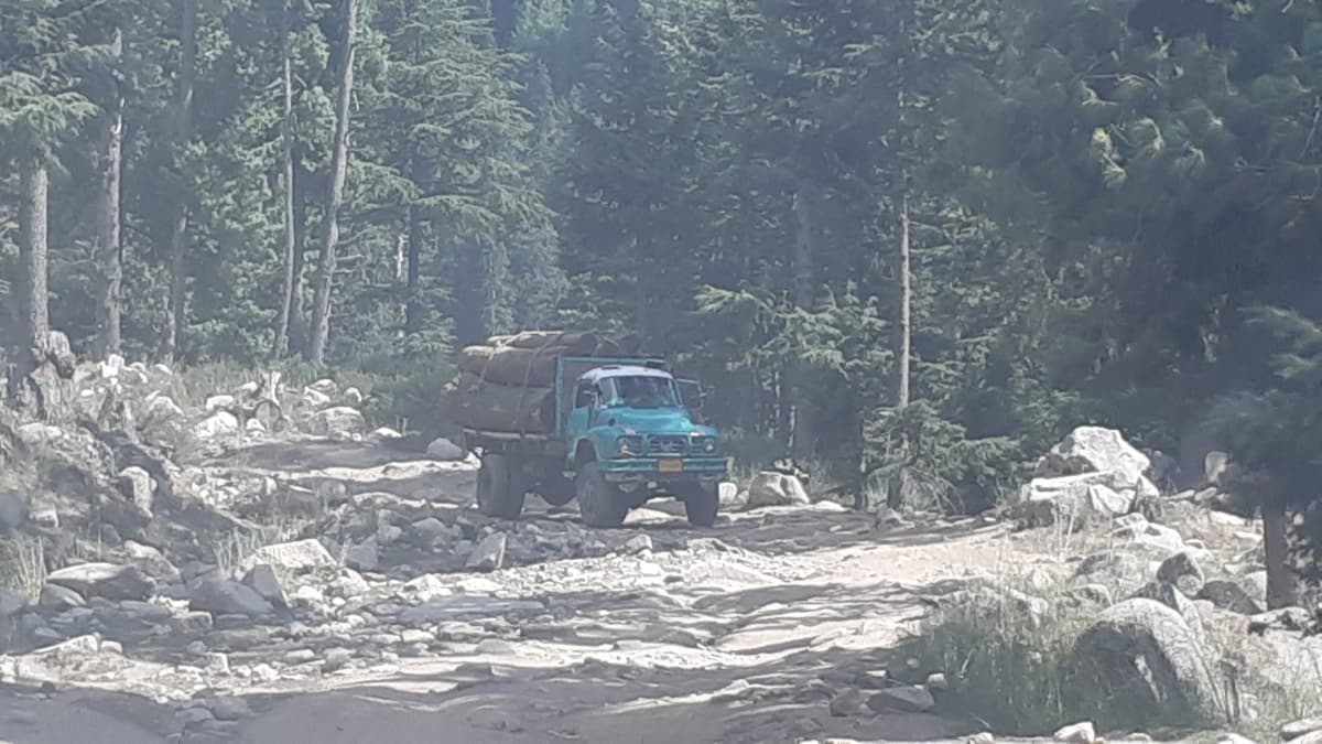
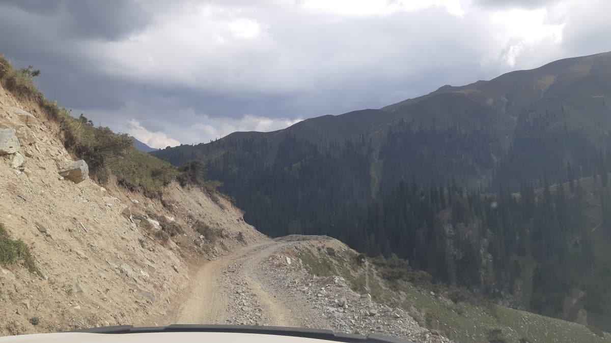
It was now time to return and again it was a long day before we could finally sleep; we had to reach Kalam, crossing the Badawai pass. We packed our luggage at the rest house, where the friendly caretaker casually told us that the trek to Kalam was very difficult and that he had seen many people returning when they'd been halfway through. But we did not have an option here so we headed forward, but cautiously. We were in Thall bazar by noon and on our way to Kalam. Soon, the road started to vanish which was fine as we were in a high clearance SUV. After an hour or so, we had left all habitation behind and were on our own and very infrequently passed by high clearance pickups with tourists coming from Kalam or trucks loaded with timber. There were no cars to be seen here and this seemed like another country. But it was serene and beautiful. The vanished road had been replaced by rocks and we were driving at about 10 kilometres per hour. We took a turn and saw another forest rest house standing in the middle of nowhere deep in Dir country. This was the ‘Barr Goay’ forest rest house, at a height of 8850 feet, constructed in 2007 by the Dir-Kohistan forest division, Shiringal. We got down to explore it but there was nobody to be seen, which was strange. I always find an old caretaker religiously present in these forest rest houses. Perhaps, he had gone down to Thall to prepare for an impending visit? And here we were now, surrounded by jungles; nothing but tall pine jungles.


We drove on and as we were gaining height, somewhere along the way, we crossed the tree line and now we saw green and maroon mountains all around. The valley seemed to be opening up with occasional snow and glaciers around us. In about three hours from Kumrat, we reached the 3500 metres high Badawai top, which is the mountain pass between the Dir and Kalam valleys. Just before reaching Badawai top, we saw a few locals on motorbikes struggling to go up. As we neared them, one waved at us; we were also quite slow, so we stopped. He asked us for permission to climb at the back of our pick-up and before we could agree to that, he was there. Seeing him, one of his friends also climbed up our vehicle. And as I viewed in my back mirror, to my horror, he drew out a pistol from his pocket and was holding it in his hand. There wasn't much we could do at that point except recalling all the religious verses we had learned in our childhood. In a couple of minutes, we reached Badawai top where their other friends were waiting. I stopped the pick-up and the guys jumped down, came forward, and thanked profusely for our help. It took us a minute to realise that each one of them was carrying a pistol and that this was a local custom, though not a very reassuring one.
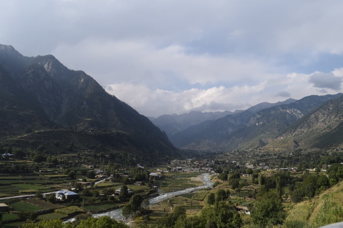
We stayed at the Badawai top for some time and had our lunch there with the treeless Dir valley on one side and the relatively green Kalam valley on the other. After taking some deep breaths in probably the cleanest spot in Pakistan, we drove forward towards Kalam. The trek from Thall to Badawai was rocky and tough for the vehicle but overall it was wide enough. However, the trek from Badawai to Kalam was pretty narrow at places. It was a downhill journey on a dirt trek and we continuously prayed that we do not encounter a vehicle from the other side. Still, a couple of times, we found ourselves eye to eye in front of another vehicle, thinking what to do. After almost a hundred narrow bends, we finally started to see the green Utror valley along with the Swat river. It was evening when we descended into civilisation; that was Utror for us. So it took us about six hours to reach Kalam from Kumrat but this was one of the most beautiful drives I have taken in my life.


Kumrat valley is one of the most beautiful and unexplored parts of Khyber Pakhtunkhwa. Unfortunately, it is fast becoming victim to rampant commercialisation and this is the time when the government should enforce strict standards of development and sound waste disposal systems in the valley and Jahaz Banda. Can't we provide the local governments in these areas with some additional funds and resources for these very basic tasks? The government may also develop the road from Kumrat to Kalam, especially from a safety point-of-view, aside from providing better policing in the area.
All photos by writer
Dr Omar Mukhtar Khan is an international development professional. He writes about travel and heritage and is the author of ‘Once upon a time in Murree’. He tweets @omk1973.


