Years of research, hard work lead to success at UN forum

KARACHI: Pakistan has recently emerged as the first North Indian Ocean country to win the claim for extension of its continental shelf.
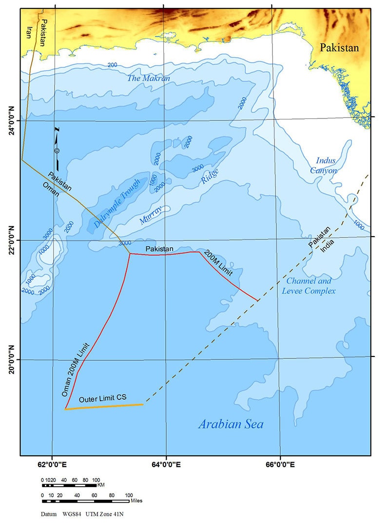
This event of great significance that passed without much media attention happened after a United Nations body of 21 members accepted Pakistan’s submission and allowed extension of its continental shelf from 200 nautical miles to the maximum 350 nautical miles. The total area gained by Pakistan is more than 50,000 sq km.
The UN body included a member from India and member from Pakistan, Commodore Mohammad Arshad SI (M), who is also the Hydrographer of Pakistan Navy.
Read: Pakistan seabed territory grows by 50,000 square kilometres
Speaking to Dawn on Wednesday about what really helped the country achieve this success, Dr Asif Inam, who headed Pakistan’s Continental Shelf Project and also a key member of the technical team at the United Nations’ Commission on the Limits of Continental Shelf (CLCS), said that the country was able to gain about 285sq km more than the area initially it claimed for.
 |
“This big achievement hasn’t come easy. We had to work hard for it over the period of 10 years. Pakistan’s case for the extension of the continental shelf was approved unanimously by the United Nations Commission on the Limits of the Continental Shelf. The entire project was finished within its initial allocation of Rs 500 million,” he pointed out.
Extension in Pakistan’s continental shelf
Dr Inam, also the director general of the National Institute of Oceanography (NIO), said the strategy that proved extremely beneficial in the case was that the team managed to collect extensive data, a lot more than what was actually suggested to the team in a desktop study conducted in collaboration with a UK group based in Southampton.
Elaborating further, he said that the minimum requirement for bathymetric data (relating to the underwater depth) as recommended in the desktop study was 4000km whereas the seismic data was required for 2,000km.
“However, the actual data acquired by the NIO was more than 11,000kms and 4,200km respectively. These efforts helped us to satisfy experts from every possible angle during the review process,” he said, adding that the review process was completed in the shortest possible time as a single error or objection to Pakistan’s submission could cause the matter pending.
Replying to a question as to why Pakistani government felt the need for an extension in the continental shelf, Dr Inam replied that the idea was conceived in the late 1990s by government officials concerned closely watching developments in the world and as the government approved the idea a navy official and some scientists were sent abroad to receive training in the area. Later, the data collection process was initiated by the NIO with the support of foreign consultants in 2005.
There are 22 countries, including Pakistan, that have successfully completed their case for extension of the continental shelf. They included Australia, New Zealand, Japan, Mexico, France, Russia and Brazil.
What Pakistan proved
Briefing about the United Nations Convention on the Law of the Sea (UNCLOS) under which the CLCS functions and how Pakistan build up its case, team member Khalid Mehmood Awan, a geophysicist working with the NIO, explained that Pakistan ratified the convention in 1997 and it came into force the same year. Under the law, Pakistan had an exclusive economic zone (EEZ) extending up to 200NM covering an area of 240,000 sq km. The continental shelf, he said, was that part of the seabed over which a coastal state exercised sovereign rights with regard to exploration and exploitation of natural resources; oil, gas deposits as well as minerals and biological resources (fishing rights remained limited to the EEZ). The legal continental shelf extended 200 NM from the coast or further if the shelf naturally extends beyond limit.
“In a case where the continental shelf extends beyond 200 NM, a state is required by the UNCLOS (Article 76) to make a submission to the relevant commission and prove scientifically that the area is the natural prolongation of the state’s land territory,” he said.
The particulars of such limits had to be submitted within 10 years of the entry into force of the UNCLOS for that state and, in Pakistan’s was, it was May 13, 2009. That was made in advance of the deadline, he said.
The government, according to Syed Mohsin Tabrez, another team member working with the NIO as geographic information system manager, assigned the project to the NIO under the administrative control of the Ministry of Science and Technology and set up two committees to supervise and execute the task.
“Scientists from NIO and hydrographers from the PN collaborated to produce high quality geo-scientific data that included a baseline geodetic survey of the entire length 990km long coastline, mapping the seabed topography identifying the location of the foot of the slope and measuring sediment thickness,” he said.
The data was submitted to the United Nations in 2009 that was followed by a presentation by Pakistan’s technical team in 2013 in New York and establishment of a UN sub-commission to have a detailed review of the data. Over the past one year, Pakistan’s technical team exchanged multiple documents and held meetings with the sub-commission. The final presentation was made before the 21-member commission last month.
“This success is for the generations to come. It’s up to us to invest in science and research, develop expertise and explore the huge resources available to us,” Mr Tabrez concluded.
Other members of the technical team were: former hydrographer/advocate general, Pakistan Navy Commodore Zafar Mansoor Tipu and deputy hydrographer of Pakistan Navy Commander Salman Ahmed Khan.
Foreign scientists that helped Pakistani team included Dr Karl Hinz, Dr Walter Roest and Dr Richard Haworth.
Published in Dawn, April 9th, 2015
On a mobile phone? Get the Dawn Mobile App: Apple Store | Google Play


