
 THE ‘kachho’ belt spread over hundreds of kilometres of un-surveyed land in the jurisdiction of Johi, K N Shah and Mehar talukas is located in the western part of district Dadu where the local people depend on rain water and cattle heads for their earnings.
These people cultivate their lands with the help of small canals of Nai Gaj Nala as they have no arrangements to store water. But the locals will be faced with a new situation once a dam is built over Nai Gaj Nala which is also the source of water for the Manchhar Lake.
In the high floods during the 1995, the Nai Gaj Nala received 380,000 cusecs of water while its people faced a draught-like situation between 1997—2003 as this belt did not receive adequate rain water.
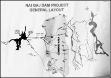
Now, the Wapda has is constructing a dam for storing rain water at the command area of Khirthar Range mountain in district Dadu at the zero point of Nai Gaj Nala which will ensure water supply throughout year. The ground-breaking ceremony of survey of Nai Gaj Dam was held in February 2005.
A decision has been made to excavate a canal at the Nai Gaj bungalow for the cultivation of 50,000 acres barren land which has sparked a controversy. The people of Taluka Johi have expressed a fear that after construction of Nai Gaj Dam, the government would not supply water to Manchhar Lake and thousand acres of their land would remain barren in their Taluka.
While the Wapda has confirmed that it would excavate a new canal, Nai Gaj Nala carries the second highest flow of water after the Indus River located in the western part of the Dadu district and is the only source of water of Manchhar Lake. And the local people are worried about the project. M. Mushtaque Choudhry, a Wapda expert on dams said the main objective of the project was the socio-economic development of the area through agricultural development, flood control, drinking water supply and fisheries development.
According to him, the salient features of the area include: the catchment area consisting on 2,460 squire miles, annual flow 0.251 maf, annual sediment 0.00136 maf and design flood 214, 000 cusecs. The height of the dam will be 150 feet and its length 3840 feet. The gross storage of water will be 174 maf, live storage 130 maf and the dead storage, 44 maf. The command area will be 50,000 acres.
Another survey expert, Bilal Ahmed said that the new canal will cultivate barren lands and the excess water will be provided to the Manchhar Lake and other parts.
Bashir Ahmed Jatoi, an assistant engineer,showing a record of Nai Gaj Nala said that the nine sluices were functioning but they have no system to control the water during the emergency while the local people were cultivating their land on these sluices.
According to him, the discharge quantity cultivation of the land on these sluices is as under:- S No Name of Sluice Discharge Quantity Cultivation Land 01 Karo Wah 1422 Cusecs 16440 Acres 02 Nao Wah 1494 Cusecs 8929 Acres 03 Sukh Nai 5272 Cusecs 12398 Acres 04 Panj loohoo 5801 Cusecs 31458 Acres 05 Haji Khan 18861 Cusecs 5137 Acres 06 Nai Gaj at RD 17.5 880 Cusecs 14494 Acres 07 Sajan Ji Paee 200 Cusecs 2004 Acres 08 Pipe at Rd 21 86 Cusecs 1050 Acres 09 Pat Gul Mohd Wah 19400 Cusecs Over then 15000 acres
Mr Jatoi further said that these sluices were supplying water to parts of Taluka Johi during the rainy season. He said that the Nai Gaj Dam water will be distributed according to the needs of the users.
During a survey, this writer came to know that the major population of the villages in Taluka Johi including Kando Babar , Bahawal Babar, Drigh Bala, Sewo Jamli, Wali Mohammad Jo Ghando, Ismail, Wasan, Sijawal Ji Katee, Shahak Rodhnani, Qasim Rodhnani always suffered when Nai Gaj flood hit the areas.
The views on the new dam however differed. Some MNAs from the area said that with the operation of the new canal, the sluices will not receive enough water and total agricultural land will become barren. They said that Manchhar Lake would be deprived of water from the Nai Gaj Nala and fishermen will face a crisis as the lake water is likely to be become poisonous.
They demanded that new canal from the Nai Gaj Dam should not be excavated and the all sluices working on Nai Gaj Nala be constructed as Pucca Canals. The Abadgars of Taluka Johi Haji Mohammad Umer Jamali, president an NGO Bakht Jamal Soomro and social workers Akbar Lashari said that after the construction of new canal, the local people and farmland of Kachho of Taluka Johi will be badly affected.
Differing, MPA from Taluka Johi, Dr Manzoor Ahmed Leghari said that this was a good project and the population of the Kachho belt in Taluka Johi will be benefited..
Meanwhile, the executive engineer, Southern Division Irrigation Department Dadu Shafqat Hussain said that the work of widening and remodelling of the canal with a cost of Rs370.124 millions, funded by the Asian Development Bank, has started at Nai Gaj Nala . The work on the protective bund will begin in April 2005.


